Angermünde
Angermünde (German pronunciation: [aŋɐˈmʏndə] ⓘ) is a town in the district of Uckermark in the state of Brandenburg, in north-eastern Germany. It is about 43 miles (69 km) northeast of Berlin, the capital of Germany. The population is about 14,000, but has been declining since its traditional industrial base, enamel-working, has declined. An administrative sub-centre of its district, it has several Protestant churches, a former Franciscan church, a number of schools of higher learning and a recently refurbished historic marketplace with an old town hall. Located in the game-filled forests of the Uckermark, with its many lakes, it now relies heavily on tourism and the sources of revenue linked to it. Since 2010, Angermünde is a federally declared resort town.[3] NameThe name Angermünde is an abbreviation of the older town of Tangermünde, for a while the town was named New-Tangermünde (Neu-Tangermünde), until it was changed to "Angermünde", with Anger being German for a central square in a town. Geography
Angermünde is located in the Uckermarck region, roughly 69 km north of Berlin. It is made up of the Inner City (German: Kernstadt), and 23 adjacent districts.[citation needed] The districts are: Altkünkendorf, Biesenbrow, Bölkendorf, Bruchhagen, Crussow, Dobberzin, Frauenhagen, Gellmersdorf, Görlsdorf, Greiffenberg, Günterberg, Herzsprung, Kerkow, Mürow, Neukünkendorf, Schmargendorf, Schmiedeberg, Steinhöfel, Stolpe, Welsow, Wilmersdorf, Wolletz, and Zuchenberg.[citation needed] In addition, there are 40 registered neighborhoods (German: Wohnplätze) within the districts.[citation needed] The registered neighborhood are: Altenhof, Augustenfelde, Ausbau, Ausbau Mürower Straße, Ausbau Pinnower Weg, Ausbau Welsower Weg, Bauernsee, Blumberger Mühle, Breitenteicher Mühle, Friedrichsfelde, Gehegemühle, Glambecker Mühle, Greiffenberg Siedlung, Grumsin, Henriettenhof, Klein Frauenhagen, Leistenhof, Leopoldsthal, Linde, Lindenhof, Louisenhof, Luisenthal, Mürow-Oberdorf, Neu-Günterberg, Neuhaus, Neuhof, Peetzig, Rosinthal, Schäferei, Sonnenhof, Sternfelde, Stolper Mühle, Thekenberg, Waldfried, Waldfrieden, Wilhelmsfelde, Wilhelmshof, Ziethenmühle, und Zollende.[citation needed] With an area of around 324 km2, Angermünde was, as of 2020, Germany's 17th largest municipality.[4] History_(Zeno_Ansichtskarten).jpg) The town was the site of a 1420 victory of Frederick I of Brandenburg over the Pomeranians.[5] Since 1687, French Huguenots settled in the town, and the Holy Spirit Chapel served as the French church.[6] From 1815 to 1947, Angermünde was part of the Prussian Province of Brandenburg. In the 19th century, the town was the seat of a Prussian circle in the Province of Brandenburg and linked to Berlin by the Berlin–Stettin (now Szczecin, Poland) railway.[7] Angermünde station then served as the junction for branch lines servicing Prenzlau, Bad Freienwalde, and Schwedt.[5] During World War II, the Germans operated five forced labour subcamps of the Stalag III-C prisoner-of-war camp in the town.[8] From 1947 to 1952, Angermünde was part of the State of Brandenburg, from 1952 to 1990 of the Bezirk Frankfurt of East Germany and since 1990 again of Brandenburg. Climate
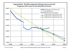
Demography
Mayors
Frederik Bewer was elected in May 2016 with 95.3% of the vote, for an eight-year term.[11] Gallery
Sons and daughters of the town
Twin cities
Notes
References
External linksWikimedia Commons has media related to Angermünde.
|
|||||||||||||||||||||||||||||||||||||||||||||||||||||||||||||||||||||||||||||||||||||||||||||||||||||||||||||||||||||||||||||||||||||||||||||||||||||||||||||||||||||||||||||||||||||||||||||||||||||||||||||||||||||||||||||||||||||||||||||||||||||||||||||||||||||||||||||||||||||||||||||||||||||||||||